Testing below the surface without causing damage
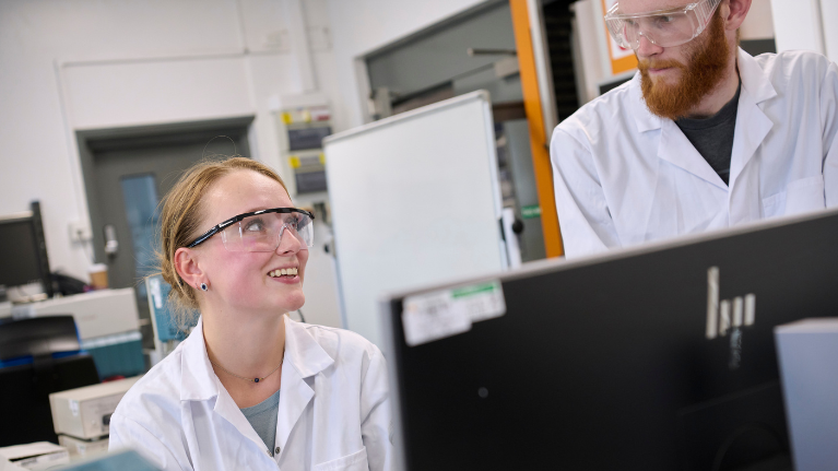
Introduction
The Faringdon Research Centre for Non-Destructive Testing and Remote Sensing has used pioneering techniques to understand the condition of both natural and manmade structures in our communities.
The work of academics in the centre has received substantial recognition across Europe and further afield with collaborations in countries including Italy, Greece, Germany, China, Japan and in the US.
How can we investigate below the surface?

The team use a variety of non-invasive techniques to understand what's going on beneath the surface, with each one giving different results.
In each project that the team works in, they combine these techniques in different ways to achieve the results they need:
- Ground-penetrating and airborne radar
- Satellite imaging
- 3D laser-scanning
- Falling weight deflectometer testing
Find out more about these techniques and the work of the Faringdon Research Centre.
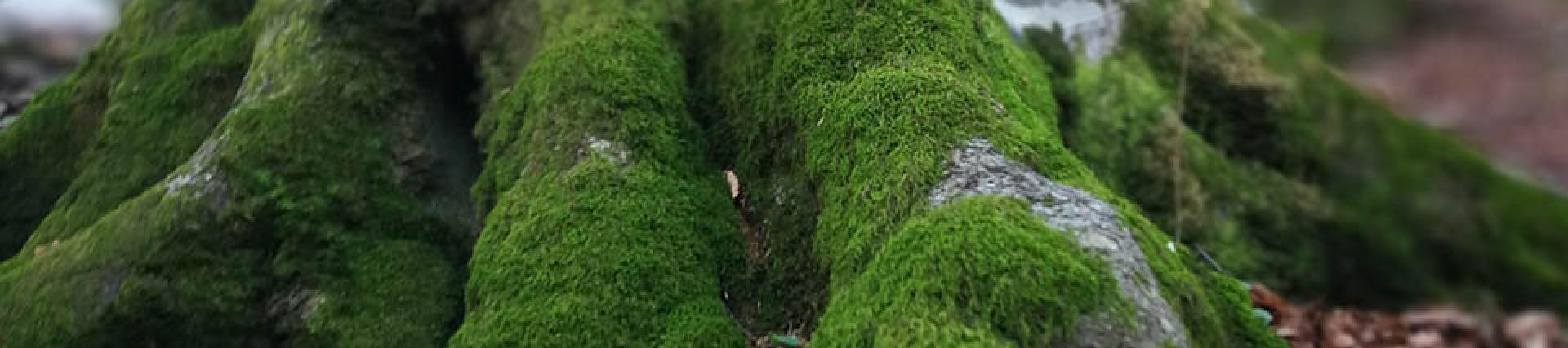
Non-destructive assessment and health monitoring of mature and ancient trees
It is often difficult to tell how healthy a tree is from its exterior. This means that trees are left to decay to a point where they are unsustainable and need to be cut down. Through a combination of analysis of the trees themselves and the interaction between their roots and the soil around them, the academics from the Faringdon Research Centre can detect early warning signs that show the tree is in danger.
Assessing tree health is a challenging and important task, as rapid interventions and prompt decisions may be needed to avoid the spread of aggressive diseases. Conventional techniques used for the monitoring of trees can result in trees having to be removed as irreversible damage has fatally endangered their integrity. This has great impact for mature and ancient trees, where conservation of protected and valuable species is essential.
Through a combination of enhanced imaging algorithms for detection of decay and cavities in trees and new data processing frameworks for mapping tree root systems’ architecture and mass density, the academics from the Faringdon Research Centre have been able to produce new predictions to locate and show the scale of decay in tree trunks and identifying tree root patterns up to a depth of 0.50m.
The Faringdon Centre works with local authorities, industries and other organisations in the area of forestry management and arboriculture to monitor tree health. The Centre is currently engaged with the assessment of the oldest Lebanese cedar tree in the UK, located in the London Borough of Hounslow.
Gunnersbury Park, London
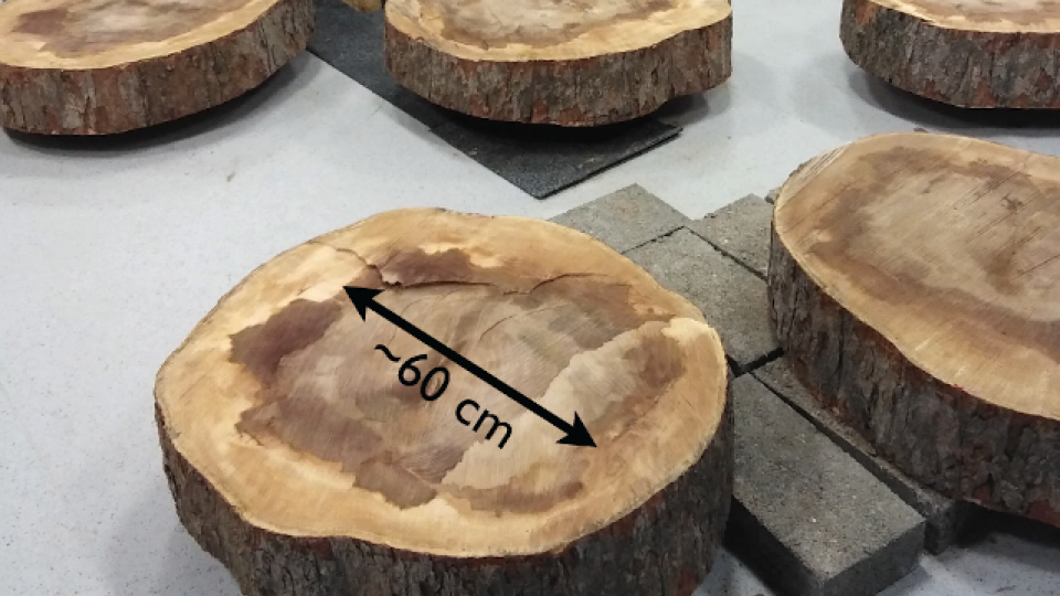
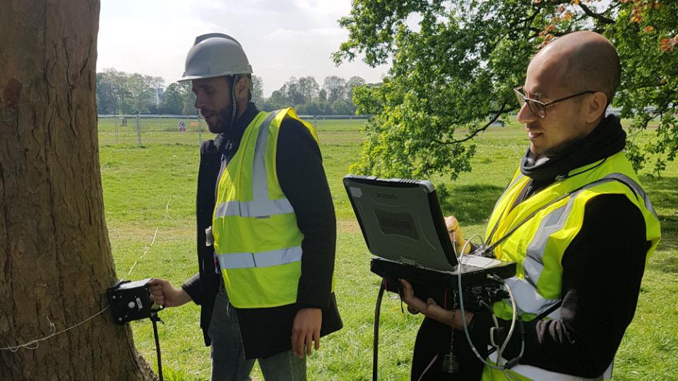
This study investigated the effectiveness of GPR, enhanced by different imaging algorithms, to assess tree trunks and detect decay from disease. A live tree in Gunnersbury Park, London, was scanned using a hand-held GPR system. The tree was then felled, and sections cut for testing. The team used the scans, within a dedicated data processing framework, to reconstruct the internal structure of the trunk. This reconstruction was then compared with the real tree sections. Results showed the viability of using GPR to identify internal features in tree trunks including the position of cavities and decay.
-
Journal articles
Alani A.M., Giannakis I., Zou L., Lantini L. and Tosti, F. (2020). Reverse-time migration for evaluating the internal structure of tree-trunks using ground-penetrating radar. NDT & E International, 115, 102294 (https://www.sciencedirect.com/science/article/pii/S0963869520303182?dgcid=rss_sd_all)
Alani, A.M., Soldovieri, F., Catapano, I., Giannakis, I., Gennarelli, G., Lantini, L., Ludeno, G. and Tosti, F. (2019). The Use of Ground Penetrating Radar and Microwave Tomography for the Detection of Decay and Cavities in Tree Trunks. Remote Sensing, 2019, 11, 2073. (https://www.mdpi.com/2072-4292/11/18/2073)
Giannakis, I., Tosti, F., Lantini, L. and Alani, A.M. (2020). Diagnosing Emerging Infectious Diseases of Trees Using Ground Penetrating Radar, IEEE Transactions on Geoscience and Remote Sensing, 58(2), 1146-1155 (https://ieeexplore.ieee.org/document/8873626)
Giannakis, I., Tosti, F., L. Lantini, and Alani, A.M. (2019). Health Monitoring of Tree Trunks Using Ground Penetrating Radar, IEEE Transactions on Geoscience and Remote Sensing, 57(10), 8317 - 8326 (https://ieeexplore.ieee.org/document/8742645)
Investigating the impact of urban trees on the built environment
As cities expand, trees are under increasing threat from pollution, disease and environmental threats. The compaction and consolidation that is inflicted from low frequency vibrations and pressures from pedestrians and vehicles can either inhibit the growth of plants and trees or lead to uncontrolled growth. The impact of these factors on tree health and urban safety is often overlooked by developers and urban planners
The Faringdon Research Centre team look at the interaction between the trees and the surrounding built environment to understand the impact that each can have on the other.
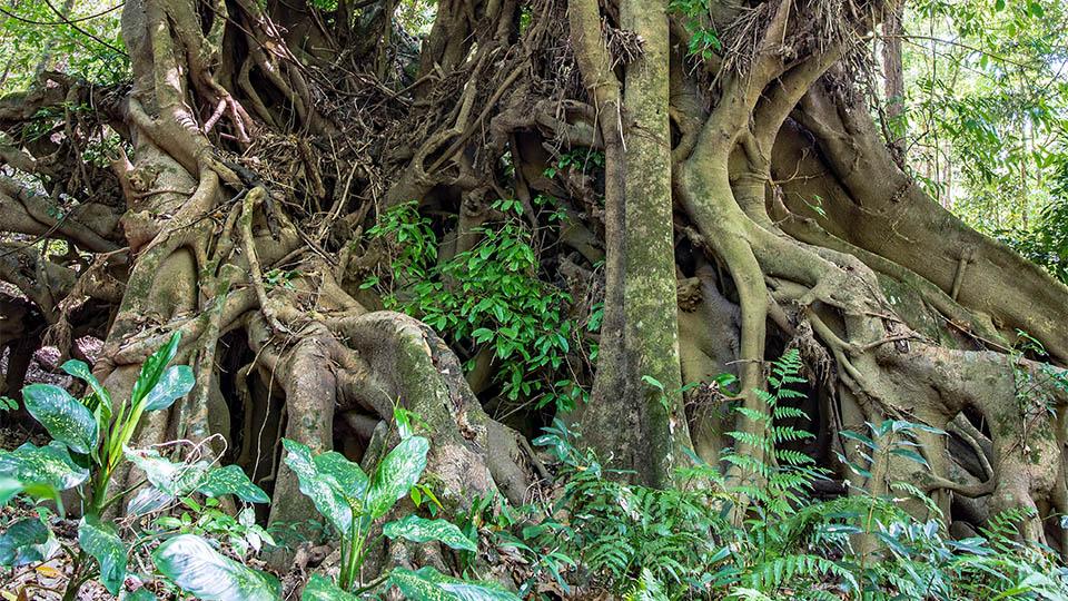
Mapping tree root interactions - Gunnersbury Park
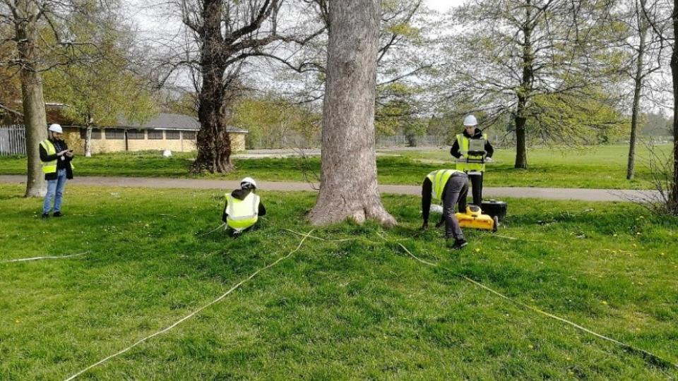
In this study, we investigated the mass density of roots in complex scenarios (eg trees at close distance and tree root systems interconnecting with major underground utilities). We used field-based experiments on tree roots and soil interaction to test our algorithms for mapping tree roots in urban environments, where root systems develop underneath road pavement sections.
Newly developed algorithms were validated by the excavation of a significant portion of the soil in the vicinity of a cedar tree in Gunnersbury Park, London. This allowed the team to accurately map the location, size and the orientation of the tree root system architecture, including the presence of other objects (eg stones or utility pipes). The topsoil was excavated in 10cm layers to a depth of 50 cm. A full GPR recognition of the area was carried out with a 700 MHz GPR antenna system. Major features, such as coarse roots and their orientation were successfully identified.
-
Journal articles
Alani, A.M., Lantini, L. Recent Advances in Tree Root Mapping and Assessment Using Non-destructive Testing Methods: A Focus on Ground Penetrating Radar. Surveys in Geophysics 41, 605–646 (2020). https://doi.org/10.1007/s10712-019-09548-6 (https://link.springer.com/article/10.1007/s10712-019-09548-6)
Lantini, L., Alani, A.M., Giannakis, I., Benedetto, A., Tosti, F. (2020). Application of Ground Penetrating Radar for Mapping Tree Root System Architecture and Mass Density of Street Trees, Advances in Transportation Studies – An International Journal, SI 2019, 3, 51-62. (http://www.atsinternationaljournal.com/index.php/2019-issues/special-issue-2019-vol3/1107-application-of-ground-penetrating-radar-for-mapping-tree-root-system-architecture-and-mass-density-of-street-trees)
Lantini, L., Tosti, F., Giannakis, I., Zou, L., Benedetto, A., Alani, A.M. (2020). An enhanced data processing framework for mapping tree root systems using ground penetrating radar. Remote Sensing, 12 (20), art. no. 3417, pp. 1-33. (https://www.mdpi.com/2072-4292/12/20/3417)
Tosti, F., Bianchini Ciampoli, L., Brancadoro, M.G. and Alani, A.M. (2018). GPR applications in mapping the subsurface root system of street trees with road safety-critical implications. Advances in Transportation Studies – An International Journal. 44, 107-118. (http://www.atsinternationaljournal.com/index.php/2018-issues/xliv-april-2018/944-gpr-applications-in-mapping-the-subsurface-root-system-of-street-trees-with-road-safety-critical-implications)
Health monitoring and assessment of structures, tunnels and bridges

As well as the natural environment, the Faringdon Research Centre team members also work with local authorities in the non-destructive monitoring of the integrity of bridges, tunnels and highways and other crucial pieces of our transport infrastructure.
This is achieved by combination of ground-based non-destructive testing and satellite remote sensing technologies. The team can provide an estimate of the health of these structures, alerting authorities to take action when needed. In this way, the work of the team helps to keep our communities moving and avoid potential catastrophes.
The outcomes of this pioneering approach have supported local authorities and asset owners to carry out remedial work on bridges.
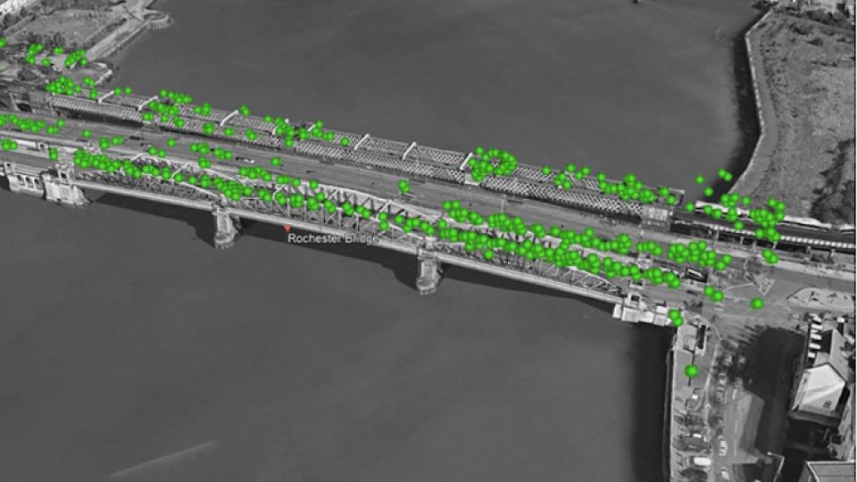
The Rochester Bridge
Satellite images provided by the Italian Space Agency were used to detect structural displacements of the Rochester Bridge in Rochester, UK. Outcomes of this investigation outlined the presence of various permanent scatterers over the inspected bridge, which helped to provide a more comprehensive monitoring method and to assess the structural integrity of the bridge.
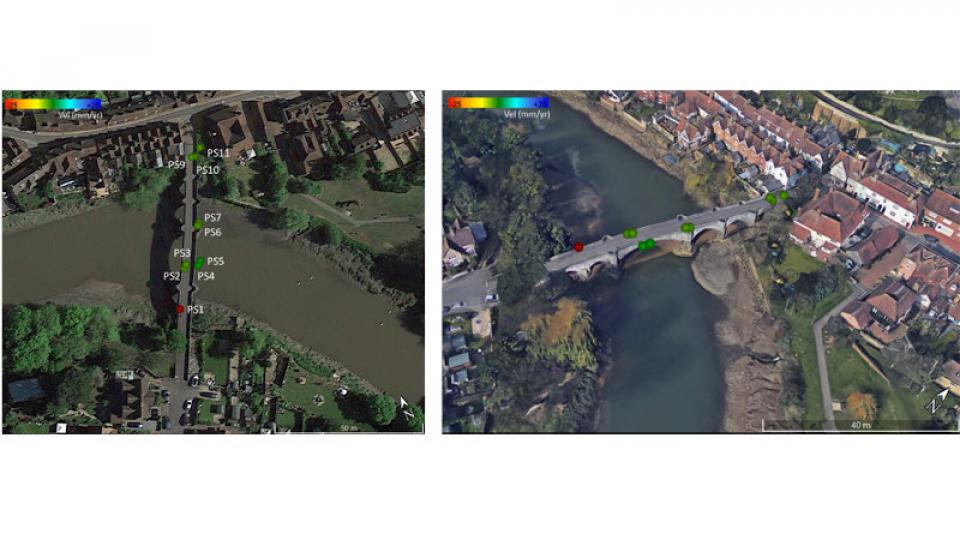
The 'Old Bridge' at Aylesford
A 13th century stone-masonry arch bridge, the “Old Bridge” at Aylesford in Kent, was investigated to demonstrate the effectiveness of using multi-source, multi-scale and multi-temporal information collected using GPR and satellite remote sensing technologies.
GPR has shown the structural detail in the subsurface geometry of the bridge as well as showing the exact positioning of the structural ties.
The use of the Interferometric Synthetic Aperture Radar technique identified measures of structural displacements caused by the seasonal variation of the water level in the river and the riverbed soil expansions.
-
Journal articles
Alani A.M., Tosti F., Bianchini Ciampoli, L., Gagliardi, V., and Benedetto, A. (2020). An integrated investigative approach in health monitoring of masonry arch bridges using GPR and InSAR technologies, NDT & E International, https://doi.org/10.1016/j.ndteint.2020.102288. (https://www.sciencedirect.com/science/article/pii/S0963869520303121)
Alani, A.M. and Tosti, F. (2018). GPR applications in structural detailing of a major tunnel using different frequency antenna systems, Construction and Building Materials, 158, 1111-1122. (https://www.sciencedirect.com/science/article/pii/S0950061817319220)
Tosti, F., Gagliardi, V., D’Amico, F. and Alani, A.M. (2020). Transport infrastructure monitoring by data fusion of GPR and SAR imagery information, Transportation Research Procedia, 45, 771-778, https://doi.org/10.1016/j.trpro.2020.02.097. (https://www.sciencedirect.com/science/article/pii/S2352146520301472)
Integrity of airfield, railway and highway foundations and infrastructures
In recent years, the application of non-destructive testing techniques such as 3D laser scanners, ultrasound techniques, fibre optic sensors, and accelerometers, as well as ground penetrating radar technologies, have been developed for to support the maintenance and management of airfield, railway and highway infrastructures.
The Faringdon Research Centre has been engaged with several projects monitoring transport infrastructures using innovative approaches based on data integration between satellite imaging and ground-based non-destructive testing methods.
The research findings have been applied by infrastructure managers in Italy to address limitations in the early-stage identification of structural decay at the foundation level (railway ballast fouling and serious differential settlements in airport runways). This information is crucial since decay processes can compromise structural integrity, and maintenance has to be prioritised against actual risk levels.
Non-destructive assessment of mechanical properties of road pavements
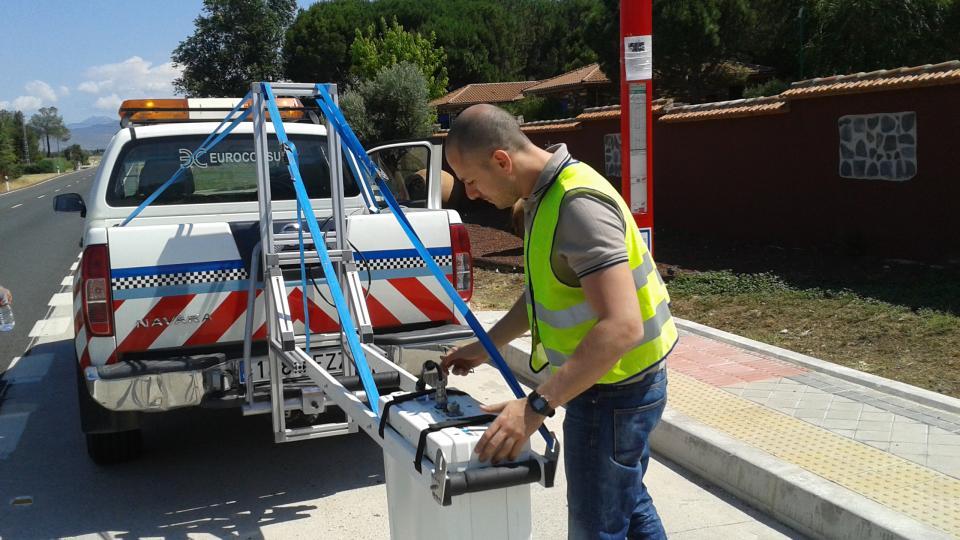
Road pavements suffer damage because of decay or weakness in their structural components. An effective assessment of the strength and deformation properties of pavement layers can identify the causes and locate the depth of the damage. This study reports the non-destructive assessment of the stiffness of road-flexible pavements using the GPR and the Curviameter techniques. In excess of 45 km of road sections were successfully investigated using GPR horn antenna systems of different central frequency of investigation.
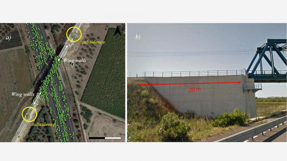
Integration of InSAR and GPR technologies for monitoring railway foundations
In May 2017, the company – Ferrovie del Gargano srl – worked with the Faringdon Research Centre to use advanced GPR technology and InSAR satellite techniques to undertake integrated health monitoring of two sections of their lines, covering inspection tasks including identifying areas of widespread ballast fouling and the monitoring of differential settlements on transition areas at the rail-bridges abutments.
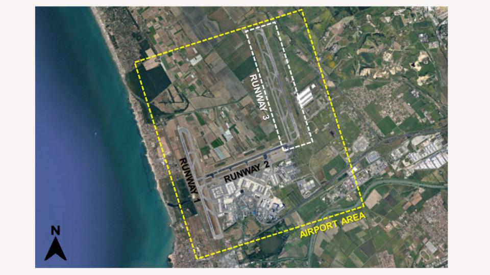
Multi-temporal InSAR technique for the monitoring of Runway 3, Leonardo Da Vinci International Airport, Rome
The Centre was also engaged with several major projects for monitoring runways and taxiways in different international airports. This included Runway 3 at the International Airport of “Leonardo Da Vinci” in Rome, Italy, in 2019, in collaboration with ASI and Roma-Tre University in Italy. The runway was subject to serious differential settlements due to consolidation of the foundation materials over time. The affected areas had previously been subject to successive remediation and repair works at significant financial cost. The scope of the project was to develop a new pavement management approach based on a systematic and integrated use of satellite data. The analysis of the medium and high-resolution data covered the period between January 2015 to April 2019 using the Persistent Scatterers Interferometry (PSI) technique. The reported results were conclusive in terms of accuracy and significance, presenting a viable alternative to conventional time-consuming methods for pavement monitoring.
-
Journal articles
Bianchini Ciampoli, L. Gagliardi, V., Ferrante, C., Calvi, A., D’Amico, F., Tosti, F. (2020). Displacement monitoring in airport runways by persistent scatterers SAR interferometry. Remote Sensing, 12 (21), art. no. 3564, pp. 1-14. (https://www.mdpi.com/2072-4292/12/21/3564)
D'Amico, F., Gagliardi, V., Bianchini Ciampoli, L. and Tosti, F. (2020). Integration of InSAR and GPR techniques for monitoring transition areas in railway bridges, NDT & E International, https://doi.org/10.1016/j.ndteint.2020.102291. (https://www.sciencedirect.com/science/article/pii/S0963869520303157)
Tosti, F., Bianchini Ciampoli, L., Calvi, A., Alani, A.M. and A. Benedetto (2018) An Investigation into the railway ballast dielectric properties using different GPR antennas and frequency systems. NDT&E International, 93, 131-140. (https://www.sciencedirect.com/science/article/pii/S0963869516303139 )
Tosti, F., Bianchini Ciampoli, L., D’Amico, F., Alani, A.M. and A. Benedetto (2018). An experimental-based model for the assessment of the mechanical properties of road pavements using GPR, Construction and Building Materials, 165, 966-974. (https://www.sciencedirect.com/science/article/pii/S0950061818302034)
Zou, L., Yi, L. and Sato, M. (2020). On the Use of Lateral Wave for the Interlayer Debonding Detecting in an Asphalt Airport Pavement using a Multi-Static GPR System, IEEE Transactions on Geoscience and Remote Sensing (TGRS), 58 (6), 4215-4224. https://doi.org/10.1109/TGRS.2019.2961772. (https://ieeexplore.ieee.org/abstract/document/8957392)
Non-destructive testing in space
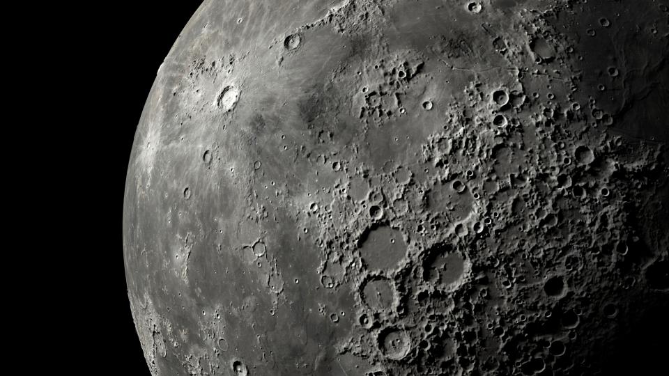
It is not only on earth that non-destructive testing techniques can be employed.
Planetary discovery and development is one of the growing areas of endeavour for scientific research and development.
The Faringdon Research Centre collaborates with the Chinese National Space Administration and other Chinese institutions to investigate the shallow structure of the Moon and the planet Mars. Thereby, to provide evidence for future research into planetary origins, development, and beyond.

Find out more
-
Research Centres
Find out about our multi-disciplinary areas of expertise, research, and teaching.

-
Research impact
Learn how our research has helped communities locally, nationally and internationally.
-
Research degrees
Find out more about PhD and Professional Doctorate opportunities and how we will support you within our active and interdisciplinary research community.